 According to a recent UN Food and Agriculture Organization (FAO) report, illegal, unregulated, and unreported (IUU) fishing may account for over 15% of fish caught (not farmed) in the global fishery. In addition to causing economic damage, these actions can threaten local biodiversity and food security in many countries. Unfortunately, none of this come as a surprise to anyone involved in global fishery management.
There is Hope for Curbing IUU Fishing
But all is not doom and gloom. Many actors are taking actions to limit IUU fishing. The UN’s Agreement on Port State Measures to Prevent, Deter and Eliminate Illegal, Unreported and Unregulated Fishing (PSMA) entered into force on June 5, 2016 and promises to be a key driver in the fight against IUU fishing. NGOs like The Nature Conservancy are partnering with fishermen and the fishing industry in collaborative projects that use science, technology and policy to ensure fishermen can have a sustainable business while protecting and restoring fish habitat. Others like Global Fishing Watch ‘advance sustainability through transparency’ by using technology to reveal the location and behaviour of commercial fishing fleets and making this information freely accessible.
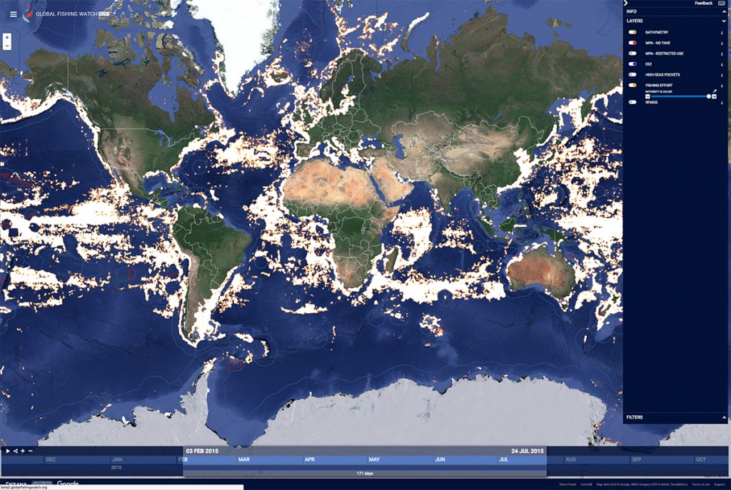
Using AIS data from ORBCOMM, Global Fishing Watch maps global commercial fishing activity with a view to fisheries sustainability.
AIS is the First Part of the Vessel Tracking Equation
Tracking commercial fishing vessels is facilitated by technologies like Automatic Identification System (AIS). The International Maritime Organization (IMO) made it mandatory for a AIS Class A transceiver to be installed aboard all ships heavier than 300 gross tons engaged on international voyages and cargo ships of 500 gross tons and upwards not engaged on international voyages by the end of 2004. Local and regional laws subsequently determined which vessels had to have a device fitted and in which waters their use was applied. In 2009, The European Union imposed even stricter regulations requiring fishing vessels 15 meters (49 feet) or longer to carry AIS.
But tracking large ships and fleets only helps with part of the problem. It’s estimated that about 85 percent of the world’s motorized fishing vessels are less than 12m in length and these small vessels dominate in all regions. AIS Class A transceivers can track these vessels but can be cost prohibitive and require permanent power which is not typically available in this size of vessel. AIS Class B products are well suited to tracking this class of vessels, however there are some challenges here as well.
AIS Class B typically transmits with less power and less frequently than Class A equipment. In areas where there are not many vessels, AIS ground stations and satellites can detect these transmissions and hence track these vessels. The challenge comes in areas with a high density of ships, for example in desirable coastal or near shore fishing areas where local authorities are particularly motivated to track fishing activity. When there is a high density of ships with corresponding high levels of AIS traffic, detection and reception of these transmissions becomes difficult, particularly when masked by higher power Class A transmissions.
AIS + M2M = Vessel Tracking for Fleets of All Sizes
The best way to ensure reliable tracking of small vessels independent of ship density and AIS traffic levels is to add another tracking modality to the dual mode AIS Class B equipment. Adding satellite M2M tracking to a dual mode (terrestrial and satellite) Class B AIS transceiver creates a tri-mode transceiver that solves the problem of AIS messages not being received. This is a robust solution based on tried and proven technology as opposed to gimmicks that purport to resolve problems posed by the physics of radio and satellite communication.
 A partnership between trusted industry players ORBCOMM, Pole Star, and Weatherdock has resulted in the creation of Hali, the first and only tri-mode small craft tracker that combines terrestrial AIS, satellite AIS, and satellite M2M technology all into one affordable and reliable solution.
Hali was created for maritime authorities, enforcement agencies, and small craft fleet owners and operators to deliver vessel location through terrestrial and satellite AIS transmissions, which are augmented with ORBCOMM satellite M2M messaging, ensuring complete vessel visibility to maximise environmental compliance, maritime safety, and security. Tracking data can be integrated into existing regulatory and enforcement software or a standalone tracking application including geofences can be provided.
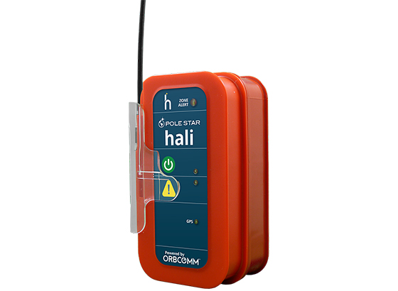
Hali, developed by ORBCOMM, Pole Star and Weatherdock, combines terrestrial AIS, satellite AIS and ORBCOMM’s proprietary satellite M2M technology all into one affordable and reliable solution. The result is that protection and accountability are no longer a luxury exclusively for bigger vessels with bigger budgets.
By deploying Hali in smaller fishing vessels, vessels that make up most of the global fishing fleet, maritime authorities and enforcement agencies have a reliable tool they can use to enforce fishing regulations and help put an end to IUU fishing.
To learn more about why AIS+M2M is a game changer in tracking IUU fishing by small vessels, visit ORBCOMM and our partner Pole Star at the World Ocean Summit. The fifth World Ocean Summit will be held at Riviera Maya, Mexico, on March 7-9, 2018 and will grapple with some of the ocean’s most intractable problems–and explore new possibilities.